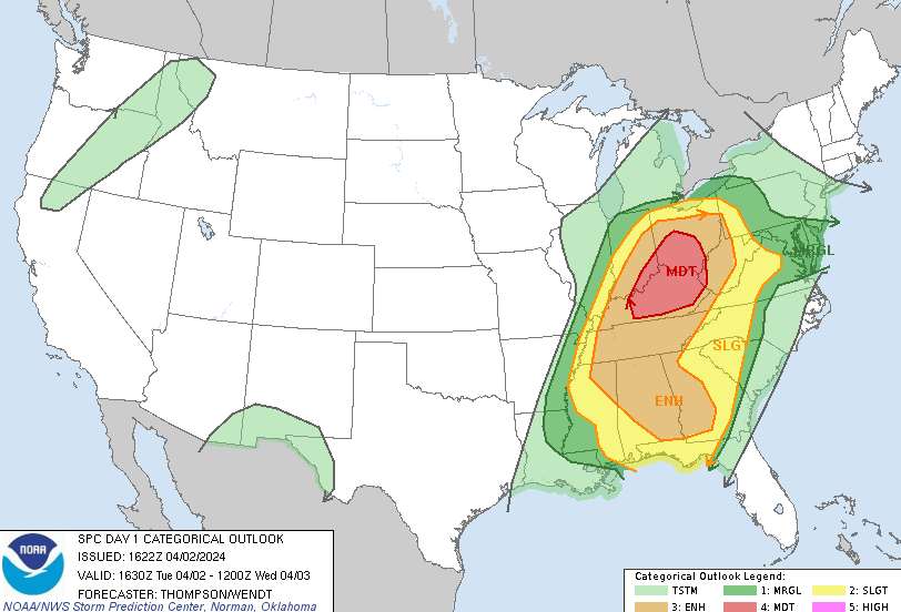
As the potential for severe weather has has made its way to today, we have a much clearer picture to paint for the possibility of severe weather in Bowling Green. The Storm Prediction Center has noticeably decreased the odds for severe weather in the Toledo metropolitan area. Bowling Green has dropped from a level 3/5 enhanced risk for severe weather, to a level 2/5 slight risk with the level 4/5 moderate risk moving farther from our area. With these adjustments, we are seeing a decrease in our odds for significant tornadoes, significant hail, and significant winds. Though this is a promising start, this is by no means an “all clear” from the Storm Prediction Center. We still have a risk for severe weather. The primary threats are damaging winds and hail, however we can not rule out an isolated tornado or two.
Although Bowling Green’s severe weather threat may have gone down, there is still the threat of severe weather occurring in portions of central and southwest Ohio, as well as much of Kentucky. Those areas are still sitting at the level 4/5 moderate risk for severe weather with the threat of a significant tornado, large hail, and damaging winds. Museums and colleges such as the Museum of the United States Airforce in Dayton, Sinclair Community College in Dayton, and the University of Kentucky in Lexington have all opted to close early today due to the threat of severe weather.
Although Bowling Green’s severe threat is lower, do not allow severe weather to catch you off guard. Just because odds of severe weather is lower does not mean that it cannot still happen. It is still recommended to be prepared and plan for the possibility of severe weather so that you are ready if dangerous weather conditions come into our area. It is encouraged to pay attention to local severe weather alerts from the National Weather Service in Cleveland as the day goes on.


