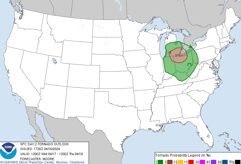
The state of Ohio has had a very busy severe weather season so far in 2024. The busy weather trend looks to continue tomorrow afternoon and evening in the Toledo area. The storms are most likely to hit between 2-6 PM. The Storm Prediction Center has issued a Slight Risk (a level 2/5) for much of Ohio, as well as southern Michigan and east central Indiana. The main threat is for hail and damaging winds, however a tornado or two cannot be ruled out. We can see that the brown circle in the image (above) has the Toledo area in a five percent risk for tornadoes. This means that if you put a point anywhere in the brown area, there is a five percent chance of a tornado happening from that point. We have a greater chance of hail and damaging winds sitting at fifteen percent under the same criteria.
Now is a good time to prepare for the possibility of severe weather. Review your severe weather safety plan if a Severe Thunderstorm Warning or Tornado Warning were to occur tomorrow. The best place to be in the case of a Tornado Warning is on the lowest level of your home or building and in the most interior room of the lowest level. For both a Severe Thunderstorm Warning and a Tornado Warning, you will want to stay away from windows as flying debris is usually the most dangerous part of the storm.
Stay tuned to the National Weather Service in Cleveland for further weather updates for Bowling Green.


